 |
 |
|
| In the 1970s,
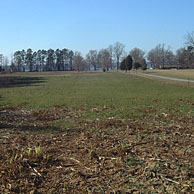
archaeologists from the Gloucester
County Archaeology Project (GCAP) found Indian and European
artifacts on the surface of the plowed fields at
Werowocomoco. |
|

Previous Archaeology at Werowocomoco (Site
44GL32*)
The site of Werowocomoco
was first registered with the Virginia Department of Historic Resources
(VDHR) in 1977 by Daniel Mouer, an archaeologist at Virginia Commonwealth
University. It was assigned the number 44GL32*. Dr. Mouer collected
artifacts from the surface of plowed fields and along the beach,
much like the current landowner Lynn Ripley. He found fragments
of Indian ceramic from the Late Woodland/Contact Period and determined
that this area was the 'possible site of Werowocomoco.' The artifacts
he collected were left with the landowners of the site.
The only other archaeologists
to work at the site were part of the Gloucester County Archaeology
Project. They excavated at Werowocomoco in 1978. They surveyed portions
of the pasture and plowed fields and excavated two 5' x 5' square
test units, but did not find evidence of Indians from the Late Woodland/Contact
Period. Very little is known about these excavations. From this
time to the present landowners have collected artifacts from the
ground surface, but no excavations were undertaken by archaeologists
until 2001.
* Each archaeological site registered with
the Virginia Department of Historic Resources is assigned a number.
The number '44' represents Virginia, the 44th state alphabetically,
without Alaska or Hawaii. The letters 'GL' are an abbreviation for
Gloucester County. The number '32' represents for the 32nd site
identified in the county. Today, Gloucester County has over 420
registered archaeological sites.
|