| |
 |
 |
|
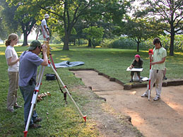
| Field school
students use a laser transit to record features found
during the excavation. |
|

The following webpage describes the results
of the 2003 field season. Click on the weblinks to hear the Werowocomoco
Research Group, landowners, and Virginia Indians describe their
impressions of the first field season.
The results of the archaeological survey
of Werowocomoco revealed a site upwards of 50 acres. Artifacts recovered
during the survey – predominantly Native pottery and stone
tools – echo the outlines of a dispersed community dating
to the centuries immediately prior to Jamestown’s settlement,
a community that continued into the colonial period of the early
1600s. Most of the Native ceramics recovered were tempered with
crushed shell and impressed on the surface with fabric textures
(known as Townsend fabric-impressed pottery) or with linear stamping
(Roanoke Simple-stamped pottery). These pottery types as well as
triangular, stone arrow heads (“projectile points” to
archaeologists) date the site to the years between A.D. 900 and
the early 1600s. Together these centuries comprise the Late Woodland
(A.D. 900 - 1607) and Contact periods in Chesapeake history. During
these years Native communities throughout the Chesapeake region
began raising corn, beans, and squash and settled villages with
50 or more residents along the banks of large rivers. Traces of
copper and glass beads found in surface collections at the site
record the Powhatan Indians’ trade with English colonists
– early colonial encounters at Werowocomoco documented by
John Smith and other colonists in written accounts of the period.
With an archaeological
survey completed, the WRG recognized the importance of informing
the Virginia Indian community about the site and its likely identity
as Werowocomoco. After consulting closely with the Virginia Council
on Indians and the individual tribes, we learned that members of
the Native community are particularly intrigued by Werowocomoco’s
long term history, including its history prior to Jamestown’s
settlement. Other members of the Virginia tribes expressed an interest
in how the Powhatan chiefdom came into being and how it developed
over time.
Since Werowocomoco represented the Powhatan
chiefdom’s political center in the early days of the colonial
era, the site offers an ideal place to study the chiefdom from a
community-based perspective. The WRG research team is also intrigued
by the ways in which Powhatan-Anglo interaction at Werowocomoco
shaped the Contact period history in the Chesapeake region. Eventually
we hope to understand Werowocomoco’s changing “cultural
landscape” (i.e. the physical and social layout of the village)
during the years before and after Jamestown’s settlement.
As a center of considerable Native authority in the Chesapeake,
Werowocomoco’s cultural landscape likely reflected the village’s
status as a place of power.
Hear Dr. Gallivan talk about the emergence
of the Powhatan chiefdom polity: Powhatan
Polity
The
Ditches
Archaeology offers an
ideal perspective for investigating such social changes over the
long-term, though archaeological research also requires the slow,
incremental accumulation of information about a site. Before beginning
to address these larger issues of Powhatan culture and history,
we began our field research with a focus on three basic questions:
- How well-preserved
is the archaeological record at Werowocomoco?
- What historical sequence of occupations is reflected in the
site’s archaeology?
- What can we learn about the overall layout of the Contact period
village?
Site Integrity
An initial step in archaeological fieldwork
involves evaluating a site’s “integrity”, or whether
the archaeological evidence remains intact or not. We knew from
the pottery and stone tools recovered during the archaeological
survey at Werowocomoco that the site was large, but we did not know
whether the remains of the village were still intact. Most of the
artifacts recovered by the survey came from the top foot of soil,
what archaeologists refer to as the plow zone. This layer of soil
contains some of the richest artifact deposits at the site, but
it has also been churned up by several hundred years of agricultural
plowing that began when English colonists seized Powhatan lands
for tobacco farming during the early 1600s. Though artifacts found
in the plow zone are informative, we are particularly interested
in finding deposits below the plow zone untouched by recent agricultural
practices. Beneath the plow zone in some village sites in the region
archaeologists have found the remnants of hearths and storage pits
that provide a record of daily activities in a Powhatan village.
Small stains in the soil left by the posts of Powhatan houses also
provide a sense of how Native communities organized their living
space within a village. Native houses were constructed of wooden
frames of saplings covered by woven matts for the walls and roof.
Such evidence of hearths, storage pits, and houses – referred
to as “features” by archaeologists – represents
some of the most informative evidence from an archaeological site.
 |
|
|
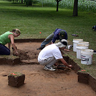
| Field school
students excavate a test
unit near the river. |
|
Site Chronology
A second initial step in archaeological
research involves understanding the history of occupations evident
at a site. As an inviting location from the earliest periods of
Native history in the Chesapeake region through today, the site
contains a complicated sequence of occupations. Understanding this
sequence was a critical step toward addressing the larger questions
of Powhatan culture and history.
Organization of Space
A third step in archaeological research
often involves efforts to understand the changing organization of
space in a community. The spatial arrangements of daily activities
within Native settlements such as Werowocomoco were influenced by
natural surroundings, including topography, soils, and adjacent
streams and wetlands. Over the course of thousands of years, Native
residents on Purton Bay altered this natural setting by raising
houses and constructing other features that formed the settlement’s
“built environment”. This built environment influenced
the ways that village residents carried out routine, daily activities
such as cooking, pottery production, and stone tool manufacture.
Archaeologists are keenly interested in the ways that such cultural
practices, natural features, and the built environment influenced
one another in a community like Werowocomoco.
Fieldwork Strategy
Our approach for addressing these research
questions at Werowocomoco included test excavations in four different
areas of the site. Two of these were located 1000 feet from Purton
Bay in a pasture, an area that contained a concentration of Native
pottery. Early historical accounts of Werowocomoco mention that
Chief Powhatans house was located a considerable distance from the
river, raising the possibility that the pasture contained evidence
of such a structure. A third area, located on the river front, also
contained a high volume of Native artifacts. A typical Powhatan
village settlement included residential areas located in such areas
lining banks of rivers. Finally, we tested an area about 500 feet
from the river and in the midst of a field currently planted with
corn. This area contained a lighter scatter of artifacts, raising
the possibility that this marked the edges of residential settlement
in the village.
Results of Field Research
Dr. Randolph Turner describes the importance
of archaeology at Werowocomoco: Archaeology
Our field research quickly revealed that
the archaeological deposits at Werowocomoco have remarkably high
integrity. In all of the excavation areas we found intact evidence
of Powhatan village life. Each one of our excavation blocks uncovered
evidence of hearths, posts, or pits.
The first area in the pasture we excavated included evidence of
both a Native and an English colonial presence. The English colonial
occupation appears to be related to a house site dating to the early
1700s. Large pit features, including one likely cellar pit, and
dense concentrations of English colonial ceramics, nails, and glass,
appeared in this area. In the same vicinity, more subtle evidence
of a Powhatan Indian presence appeared in the form of small post
stains, Native pottery, and stone tools. Though the early English
colonial occupation of the site is not central to our research,
it entails a critical part of the site’s history. It is not
uncommon in the Chesapeake region to find archaeological indications
that the earliest English colonial settlement in a location occurred
in the same physical space as a Native settlement. In some instance
this sequence reflects colonial settlement in areas previously cleared
of trees by Native residents who had recently abandoned the location.
In other instances, this evidence reflects the colonial seizure
and re-occupation of Native lands.
|
 |
|
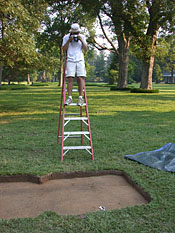
| Field school student
Justin Arrocho photographs a test unit after the plowzone was
removed. |
|
The second excavated area in the pasture
revealed fewer English colonial artifacts and more Native materials.
Upon excavating through the plow zone, we also uncovered two linear
soil stains that ran parallel to one another. The stains were roughly
three feet wide, two feet deep, and separated by a distance of about
6 feet. They extended beyond the length of our excavation block
of 25 feet. These features, that appeared upon excavation to be
refilled ditches, contained only Native artifacts. A few, scattered
post stains appeared within or immediately outside of the ditch
features. Within one of the ditches an area of charcoal, burned
soil, fire-cracked rock, and Native pottery marked the presence
of a hearth. Though not unprecedented, such ditch features are highly
unusual for Native sites in the region. In fact, the evidence of
an English colonial occupation in the same general area of the site
raised the possibility that the ditches were actually constructed
by early English settlers. The absence of any identifiably English
materials in the ditches and the presence of Native pottery and
stone tools argues for the interpretation that the ditches were
constructed by Native residents of the site. The ditches are particularly
intriguing given that the site was the capital of the Powhatan chiefdom.
Whether the features were created as part of a defensive palisade,
to demarcate space in a special area of the site, or for some other
purpose is not yet clear.
Along the river front in the third excavation area, our investigations
confirmed the impression that this area contained the highest density
of Native artifacts on the site. Pottery, stone tools, and fire-cracked
rocks from hearths indicated that this area saw a range of activities
associated with residential space. A piece of copper from this area
may reflect early seventeenth century trade relations involving
Native residents and English colonists. We also uncovered a dense
scatter of post stains in this area of the site, most of which are
likely related to the construction of Native houses.
The final excavation area in the cornfield uncovered layers of soil
beneath the plow zone that contained Native artifacts. Such cultural
layers rarely survive intact and unplowed within archaeological
sites in the region. The buried cultural layers at Werowocomoco
are particularly intriguing since they appear to record a sequence
of living surfaces dating to the site’s late precontact and
early colonial occupations. One of these living surfaces included
post stains which contained sherds of Native pottery, an encouraging
sign of intact architectural evidence at the site.
Preliminary Conclusions
Werowocomoco in context: Context
While the first season of excavations
at the site was remarkably successful, we still have much more excavation
and analysis to do before we begin to have a firm understanding
of the site’s long-term history. We have learned that the
site contains intact features and living surfaces from the late
precontact through early colonial eras. Most of the artifacts and
features we identified date to the Late Woodland and Contact periods
that comprise the site’s Werowocomoco era. It appears that
the core of residential settlement and domestic activities is located
on the river front. We see indications that this residential living
space extended at least 500 feet into the corn field, pointing toward
a large, dispersed community. Finally, the unusual ditch features
located in the pasture provide a tantalizing glimpse of the demarcation
of space in the settlement.
|