|
|
| |

The six week field season during the 2003
summer drew on the results of the survey by opening up approximately
1400 square feet in four areas of the site. Questions driving this
initial testing of the site included those related to site integrity,
chronology, and spatial organization. On the whole, the initial
field season at Werowocomoco demonstrated that the site possesses
remarkably high integrity, that the bulk of the site is dominated
by a transitional Late Woodland / Contact period village, and that
large features from both the Native and colonial occupations record
substantial landscape modification at the site. We recovered evidence
of exchange patterns from the precontact era in the form of non-local
lithics and ceramics, while evidence of Contact period trade relations
appeared in the form of copper objects from the Purton Bay waterfront.
Flotation of all feature soils is now nearing completion, and a
preliminary sorting of this material points to excellent preservation
of paleoethnobotanical remains.
|
| |
|
|
| |
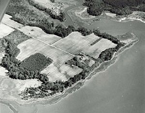
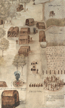
Above
left: Aerial photo of Purtan Bay; above right, a 16th century watercolor
of the town of Secotan in North Carolina. |
| |
Excavation Areas
The first excavation block, located near the Purton
Bay shoreline, uncovered a dense array of post stains, Native pottery
(Townsend fabric impressed and Roanoke Simple stamped), stone tools,
and fire-cracked rock - material consistent with the residential
core of a Late Woodland / Contact period village. The Powhatans
constructed their houses with sapling frames and woven mat walls
and roofs. Such architecture often leaves behind indications of
the structural footprint in the form of post stains. The excavations
also revealed a slot trench in the northeast portion of the block
that contained post stains and Native artifacts. The feature may
represent a palisade line dating to the Werowocomoco occupation
of the site.
|
| |
 |
 |
| |
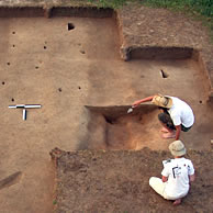
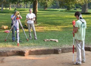
Above left:
surveying in Block 1; above right, a feature consisting of a row of
postholes |
| |
A
smaller second excavation block located at a slightly higher elevation
500 feet from the shoreline identified additional post stains containing
Townsend fabric-impressed pottery. Beneath the plow zone we encountered
unplowed cultural deposits containing solely Native artifacts. This
unplowed "A horizon" appears to represent a remnant living surface
from the Late Woodland / Contact transition. |
| |
|
| |
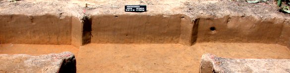
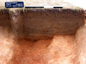
Above
is a profile showing the A horizon, which serves as a marker for possible
Woodland / Contact transition living floors. The stratum is a brighter
color and is higher on the left hand side, trending down towards the
right. Click on the image to see a larger version.of the profile. |
| |
A
third excavation block located almost 1000 feet from the shoreline
exposed two parallel ditch features. In plan the ditches ran approximately
2-3 feet east-west and over 25 feet north-south, continuing beyond
the bounds of the excavation block. The ditches were approximately
1.5 feet deep in profile with a series of lenses suggesting that the
features filled slowly over time. Within one of the two ditches we
identified a hearth feature containing fire-cracked rock and several
Roanoke simple-stamped sherds. All of the artifacts recovered from
the ditch features were Native (lithic debitage, shell-tempered pottery,
and fire-cracked rock) even though English colonial artifacts occurred
in the plow zone above the features. Given this juxtaposition, the
ditches were either dug and filled extremely early in the English
colonial occupation of the site, possibly as boundary ditches, or
they are remarkably prominent Native landscape features. Two burned
tap roots appeared at the base of one of features, raising the possibility
that trees were cleared in order to construct the ditches. There is
no clear evidence of post stains at the base of the ditches, pointing
toward landscape features excavated for the purpose of demarcating
space. Similar features are apparent at other Native sites in the
region, including the Potomac Creek site in the Potomac River drainage
and at the Buck site on the Chickahominy River. Our working hypothesis
at this stage is that the ditches represent Native features associated
with the Werowocomoco phase of the site. We currently await the results
of two radiocarbon assays from the features, though in truth an early
colonial date with an error factor of 50 or more years may not allow
us to confirm the identity of the features as Native or English. Better
understanding of these features requires additional excavation |
| |
|
|
| |
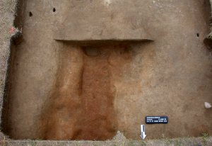
Above left is a plan view of one
of the excavated ditches; above right is a section through one of
the ditches.
|
| |
A
fourth excavation block located just over 1000 feet from Purton Bay
identified evidence of a late seventeenth century through early eighteenth
century English domestic site. A light distribution of Late Woodland
/ Contact Native ceramics and Native post stains were interspersed
within the materials and features associated with what appears to
be the earliest English colonial occupation of the site. As noted
by other researchers, it is not uncommon to find the earliest colonial
presence in areas cleared and inhabited by previous Native communities.
This history of land use likely resulted partly from English efforts
to profit from Native identification and clearing of the most fertile
floodplain locations. Yet it is important to remember that the seizure
and occupation of Native habitations also represented a deliberate
transformation of the natural landscape that paralleled the English
colonial usurpation of Powhatan lands. |
| |
|
| |
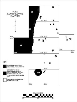
A
plan drawing of Block 1B. This is the open area excavation near the
bay and the current residence. Click on the image to see a larger
version. |
| |
Conclusion
Perhaps most importantly, evidence recovered during
the initial field season at Werowocomoco provides a tantalizing
glimpse of substantial landscape features within the settlement.
The possible palisade feature within the residential core of the
site raises the possibility that Werowocomoco's residents segmented
space in meaningful ways. The large ditch features are still enigmatic,
yet all indications point to the likelihood that these features
represent prominent elements of the Native landscape of Werowocomoco.
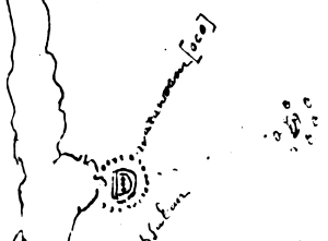
John Smith made no mention of such ditch features in his accounts
of Werowocomoco, though the early seventeenth century Zuniga Map
may offer important clues. The map was sent by Pedro Zuniga, Spain's
ambassador in London, to Spanish King Phillip III in 1608, apparently
to keep the King abreast of English colonial activities in North
America. The original source of the map is unknown, though it appears
to be a copy of a map John Smith sent to England with his True Relation
that never reached its destination. Notation on the map includes
the path Smith took during his December 1607 - January 1608 captivity
and scattered dots that appear to represent dispersed house locations
in some Powhatan villages. At Werowocomoco the cartographer added
an unusual set of symbols that appear as a set of dots surrounding
a double "D" shaped pattern. Within the two "D"s are three additional
dots. The significance of this notation is elusive, yet the archaeological
research at Werowocomoco raises the intriguing possibility that
the Zuniga Map records large landscape features at Werowocomoco
that were subsequently forgotten. Additional investigation of the
ditch features at the site will allow this idea to be tested archaeologically.
|
| |
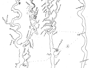
Below
left is the Zuniga map of 1608; below right, a detail showing 'Waruwocomoco'.
Click each map to see a larger version. |
| |
 |
 |